
2020 Annual Report
[View PDF]
[View PDF]

2019 Annual Report
[View PDF]
[View PDF]

2018 Annual Report
[View PDF]
[View PDF]

2017 Annual Report
[View PDF]
[View PDF]
 On the Feasibility of Implementing an Earthquake Early Warning (EEW) System in Utah (2023)
UUSS worked with the Utah Geological Survey and Utah Department of Emergency Management to assess if an EEW system in Utah could feasibly provide meaningful earthquake alerts for residents and stakeholders in the state, particularly in the Wasatch Front region. The report examined potential warning times for realistic earthquake scenarios, probable frequency of use, and assessed the changes needed to get the current seismic network EEW-ready.
[Also see our 1-page summary]
On the Feasibility of Implementing an Earthquake Early Warning (EEW) System in Utah (2023)
UUSS worked with the Utah Geological Survey and Utah Department of Emergency Management to assess if an EEW system in Utah could feasibly provide meaningful earthquake alerts for residents and stakeholders in the state, particularly in the Wasatch Front region. The report examined potential warning times for realistic earthquake scenarios, probable frequency of use, and assessed the changes needed to get the current seismic network EEW-ready.
[Also see our 1-page summary] 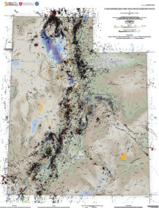 Earthquake database for Utah Geological Survey Map 277: Utah earthquakes (1850–2016) and Quaternary faults: Utah Geological Survey Open-File Report 667 (2017)
The Utah Geological Survey (UGS), University of Utah Seismograph Stations (UUSS), and Utah Division of Emergency Management (UDEM) recently published the Utah Earthquakes (1850–2016) and Quaternary Fault Map (UGS Map 277). The new map shows earthquakes within and surrounding Utah from 1850 to 2016, and faults considered to be sources of large earthquakes.
[Also see Utah Earthquake Map Catalog page]
Earthquake database for Utah Geological Survey Map 277: Utah earthquakes (1850–2016) and Quaternary faults: Utah Geological Survey Open-File Report 667 (2017)
The Utah Geological Survey (UGS), University of Utah Seismograph Stations (UUSS), and Utah Division of Emergency Management (UDEM) recently published the Utah Earthquakes (1850–2016) and Quaternary Fault Map (UGS Map 277). The new map shows earthquakes within and surrounding Utah from 1850 to 2016, and faults considered to be sources of large earthquakes.
[Also see Utah Earthquake Map Catalog page]  Earthquake Probabilities for the Wasatch Front Region in Utah, Idaho, and Wyoming (2016)
The Working Group on Utah Earthquake Probabilities presents probabilities of future occurrence of moderate-to-large earthquakes in the Wasatch Front region, including the Wasatch fault zone, the Oquirrh-Great Salt Lake fault zone, and other significant faults in the region. The probability of a magnitude 6 or greater occurring on any Wasatch Front fault in the 50 years following the study (2014-2063) is 57%; the probability of a magnitude 6.75 or greater is 43%.
[Also see 2-page USGS Fact Sheet for this report]
Earthquake Probabilities for the Wasatch Front Region in Utah, Idaho, and Wyoming (2016)
The Working Group on Utah Earthquake Probabilities presents probabilities of future occurrence of moderate-to-large earthquakes in the Wasatch Front region, including the Wasatch fault zone, the Oquirrh-Great Salt Lake fault zone, and other significant faults in the region. The probability of a magnitude 6 or greater occurring on any Wasatch Front fault in the 50 years following the study (2014-2063) is 57%; the probability of a magnitude 6.75 or greater is 43%.
[Also see 2-page USGS Fact Sheet for this report]  Scenario for a Magnitude 7.0 Earthquake on the Wasatch Fault - Salt Lake City Segment (2015)
The Scenario for a Magnitude 7.0 Earthquake on the Wasatch Fault-Salt Lake City Segment: Hazards and Loss Estimates report provides information about the effects of the Wasatch fault scenario earthquake-in particular, how long it may take the state of Utah and its residents to fully recover and the potential long-term impacts on Utah's economy. The ultimate goal of this report is to catalyze public and private actions that will increase pre-disaster resiliency through earthquake preparedness-being prepared to WITHSTAND, to RESPOND, and to RECOVER.